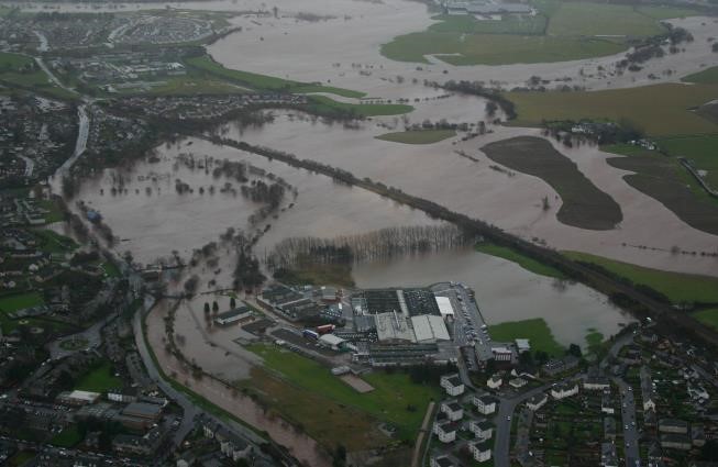
We recently saw the dramatic effect heavy rainfall and snowmelt can have on our village with Hawes Park, the allotments and a section of Cornton road being flooded on February 20th. In addition Henderson street often floods with rainwater at the Memorial Park causing further travel disruption.
Thanks to Katy Joy Whitelaw for use of her video. Credit to SEPA for the aerial image of flooding from 2006.
The impacts could have been more disrupting and damaging if we did not have any flood protection in the village. The current protection measures are now ageing and Stirling Council are exploring the options to replace them.
How can you find out more
In our November meeting Stirling Council’s Operations Team Leader Maria Lucey gave us a presentation explaining the state of the existing defenses, overview and costs of the range of options considered. Stirling Council now have a number of in person and online opportunities for you to find out more and feedback your views.
Project Website
The project has a dedicated website full of useful information and links to the consultation and events. On this site you will be able to:
-
- Find out the background to the project
- Learn about the flood protection options
- View a Flood Extent Map of the area
- Complete an online survey about the proposed options
- Suggest additional options that are not currently considered
Bridge of Allan Library
Printed copies of the information are available to view at the Library during its normal opening hours. These will be available until March 21th.
Online Events
Two online presentations will be held on the evenings of the 8th and 14th of March 7-8pm. To attend you should sign up using this online form. Recordings of the presentation will be made available after the events.
In Person Events
Three in person sessions are available for anyone to drop in.
- Thursday 10th March, 14:00 – 18:00, Fire Station, Cornton Road
- Friday 11th March, 11:00 – 15:00, Provost Park, Henderson Street (Opposite Westerton Arms)
- Wednesday 16th March, 14:00 – 18:00, location Co-Op Car Park, 12 Fountain Road
What’s next?
This is the early stages of Information Gathering to understanding everyone’s views and preferences. A long list of options will be generated based on all feedback from stakeholders. Then long list appraisal work will be undertaken to determine a short list of viable options. These will be further explored and eventually deciding on a preferred option that will be taken forward for detailed design.


serious consideration must be given to no more building being permitted on the flat, carse lands in and around the village. The run off from roads, buildings, patios and hard core contributes to the flooding considerably.
I live in Bridge of Allan, up stream from the main area of concern, however I have worries about the possible flooding and damage done to the riverbank near my apartment at Allan Walk. Some months ago I passed on my concerns to Stirling Council, through Councillor Tollemache after a section of the banking collapsed. In response I was informed that SEPA are quire firmly against Gabion Baskets as means to protect the riverbank. Unfortunately, this is not what I expected to read, this area does not have the luxury of having a suitable area to be flooded. One riverbank is steeply sloping to height of 6/7 metres, on the other bank we are only a few metres from our buildings. I have photos taken in December 2015 when there was enough water in the river to overflow into our garden, a close call, I would say. I am still waiting for some formal report from Stirling Council after my inquiry, please note the following reference: SLA Deadline: 08/10/2021
Lagan Ref: 101000680012
Thank you.